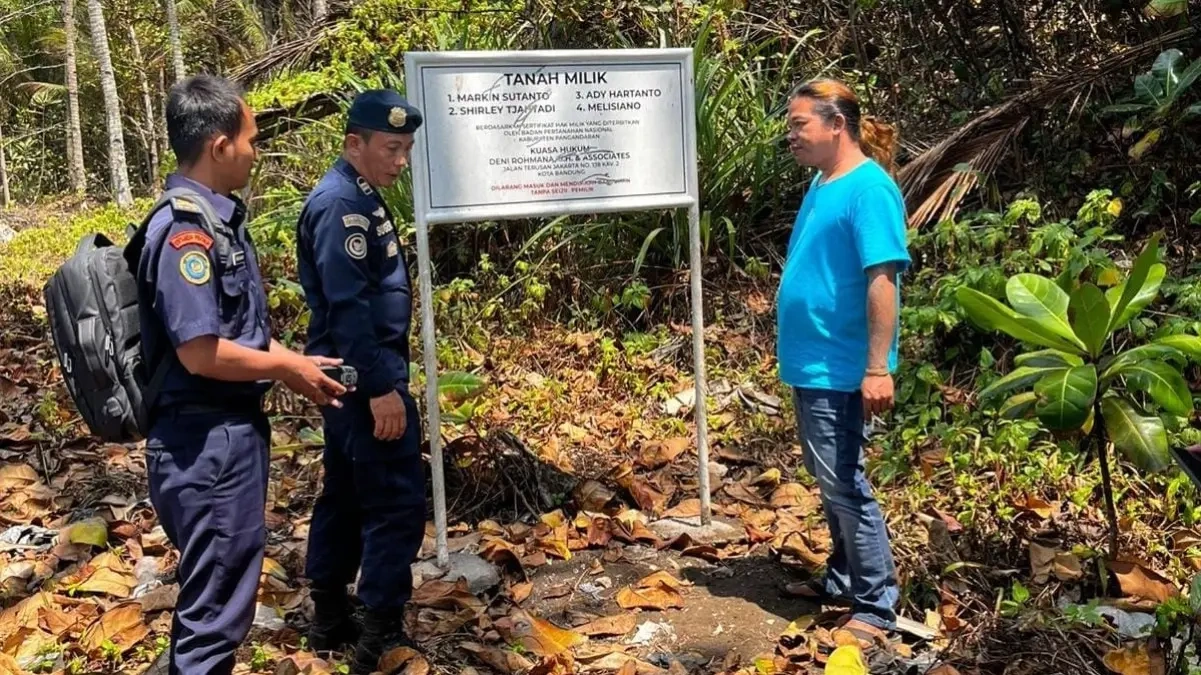
PANGANDARAN, Thecuy.com – The controversy over the certified sea border at Pantai Madasari, Masawah Village, Cimerak District, is now receiving attention from the central government. The Ministry of Marine Affairs and Fisheries (KKP) has sent an officer to Pangandaran.
The appointed officer is the Marine Supervisor/Polsus PWP3K at the Jakarta PSDKP Port, Sugeng Riyadi. He said his team is following up on a report concerning alleged coastal fringe land or sea border land that is said to have a private ownership certificate.

“We were assigned by PSDKP Jakarta due to a complaint about the sea border or the Madasari coastal area that has a private land certificate,” he told reporters on Wednesday (2/9/2026).
Maulid yang Menanti Wali Kota!Audiensi di DPRD Tasikmalaya, Vendor Ungkap Skandal Parkir
According to Sugeng, the team not only inspected the site but also gathered information from various parties. Data were collected from residents, fishermen, and the Masawah Village Government.
This step was taken to verify the position of the certified land plot relative to the coastal area boundary. “We will map the results, then confirm them with West Java’s coastline. From there, it will be determined whether it legally falls within the sea border or the coastal fringe,” he explained.
Sugeng added that, based on initial field observations, there is an indication that part of the disputed land plot lies within the visually apparent coastal fringe boundary. He mentioned that the initial reference used is a distance of 100 meters from the highest tide point.
“Based on current visual observation, from 100 meters of the highest tide point, the allegedly certified area appears to be within the sea border or coastal fringe,” he said.
Nevertheless, Sugeng stressed that the result cannot yet be considered a final conclusion. His team still needs to map based on coordinate data and compare it with the coastline and existing land data.
“The certified land cannot yet be confirmed because we have not conducted data mapping. However, visually, part of it appears to be within the sea border or coastal fringe,” he said.
During the initial data collection, the team reportedly discovered at least six certificates, with the possibility of more being found. However, Sugeng explained, they did not immediately map all the land plots.
Check out other stories on the News Page
Thank you for visiting thecuy . 🙂

Saya adalah jurnalis di thecuy.com yang fokus menghadirkan berita terkini, analisis mendalam, dan informasi terpercaya seputar perkembangan dunia finansial, bisnis, teknologi, dan isu-isu terkini yang relevan bagi pembaca Indonesia.
Sebagai jurnalis, saya berkomitmen untuk:
Menyajikan berita yang akurasi dan faktanya terverifikasi.
Menulis dengan bahasa yang mudah dipahami, namun tetap menjaga integritas jurnalistik.
Menghadirkan laporan mendalam yang memberi perspektif baru bagi pembaca.
Di thecuy.com, saya tidak hanya melaporkan berita, tetapi juga berupaya menganalisis tren agar pembaca dapat memahami konteks di balik setiap peristiwa.
📌 Bidang Liputan Utama:
Berita Terbaru & ekonomi, keuangan.
Perkembangan teknologi dan inovasi digital.
Tren bisnis dan investasi.
Misi saya adalah membantu pembaca mendapatkan informasi yang cepat, akurat, dan dapat dipercaya, sehingga mereka bisa membuat keputusan yang lebih cerdas dalam kehidupan sehari-hari maupun dunia usaha.
📞 Kontak
Untuk kerja sama media atau wawancara, silakan hubungi melalui halaman Kontak thecuy.com atau email langsung ke [email protected].